![]()
Ft.
Abraham Lincoln State Park
Mandan, ND
| Back | Return to Index Page |
|
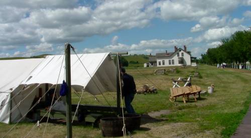
Fort Abraham Lincoln Infantry Post This United States military post was established as Fort McKssa, June 14. 1872 by companies "B" and "C" of the 6th Infantry under the command of Lieutenant-Colonel Daniel Huston, Jr. It was named in commemoration of Colonel H. Boyd McKeen of the 81st Pennsylvania Volunteers, who lost his life in the Battle of Cold Harbor during the Civil War. The name of this post was changed to Fort Abraham Lincoln on November 19. 1872. With the establishment of the cavalry post the next year on the flat below, the name Fort Abraham Lincoln designated both garrisons. The primary purpose of. these posts was to protect the surveyors and construction parties of the Northern Pacific Railway. Indian raids at and near this site were quite common during 1872 and 1873. On a number of occasions small detachments of troops from the post were attacked by Indians lying in ambush along the trail a short didtance from the fort. Favorite spote for these ambuscades were the brushy ravines immediately to the north of the blockhouses. In several instances the Indians forced the soldiers to return to the blockhouses where additional help was summoned to drive the Indians away. When the Fort Lincoln troops were engaged in the Campaign of 1876 the Indians attacked the outer guards at this post on several occasions. During the Most active years of Fort Abraham Lincoln, infantry troops were stationed at this site while the cavalry troops were stationed at the cavalry post below. In the latter years of Fort Lincoln the Government dismantled the buildings on this site and moved the lumber down to the cavalry post. After thla time the troops were stationed at the cavalry post only. The present blockhouses were restored in 1955 on the original sites. |
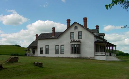
The Custer House
It was from this fort that Lt. Col. George Armstrong Custer
and the Seventh Cavalry rode out on their ill-fated
expedition against the Sioux at the Little Big Horn.


|
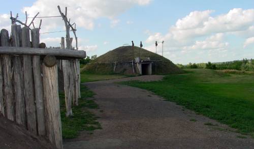
Slant -Indian Village Slant Village was occupied by the Mandan, an agricultural Indian tribe, and received its name because of the sloping ground upon which it was situated. The village embraced about seven or eight acres of ground and the most recent survey of the site, made in 1937, revealed the ruins of seventy-five earth lodges. The readily visible circular depressions on this site mark the ruins of the lodges. A study of the tree rings from timbers found at this site indicates that Slant Village was occupied during the period of 1650-1750. In the fall of 1804. when the Lewis and Clark Expedition moved- up the Missouri River, this village was in ruins. At that time the Mandan tribe was living in the vicinity of the Knife River, some 60 miles up the Missouri River. |
| Back | Return to Index Page |